
The mission of the CEOS Land Product Validation (LPV) subgroup is to coordinate the quantitative validation of satellite-derived products. The focus lies on standardized intercomparison and validation across products from different satellite, algorithms, and agency sources.
The sub-group consists of 10 Focus Areas, with 2/3 co-leads responsible for each land surface variable (essential climate and biodiversity variables).
CEOS VALIDATION HIERARCHY
| Validation Stage - Definition and Current State | Variable | |
| 0 | No validation. Product accuracy has not been assessed. Product considered beta. |
|
|---|---|---|
| 1 | Product accuracy is assessed from a small (typically < 30) set of locations and time periods by comparison with in-situ or other suitable reference data. |
Snow Fire Radiative Power |
| 2 | Product accuracy is estimated over a significant (typically > 30) set of locations and time periods by comparison with reference in situ or other suitable reference data. Spatial and temporal consistency of the product, and its consistency with similar products, has been evaluated over globally representative locations and time periods. Results are published in the peer-reviewed literature. |
fAPAR |
| 3 | Uncertainties in the product and its associated structure are well quantified over a significant (typically > 30) set of locations and time periods representing global conditions by comparison with reference in situ or other suitable reference data. Validation procedures follow community-agreed-upon good practices. Spatial and temporal consistency of the product, and its consistency with similar products, has been evaluated over globally representative locations and time periods. Results are published in the peer-reviewed literature. |
Vegetation Indicies LST & Emissivity Active Fire Burned Area |
| 4 | Validation results for stage 3 are systematically updated when new product versions are released or as the interannual time series expands. When appropriate for the product, uncertainties in the product are quantified using fiducial reference measurements over a global network of sites and time periods (if available). |
|
VALIDATION FRAMEWORK
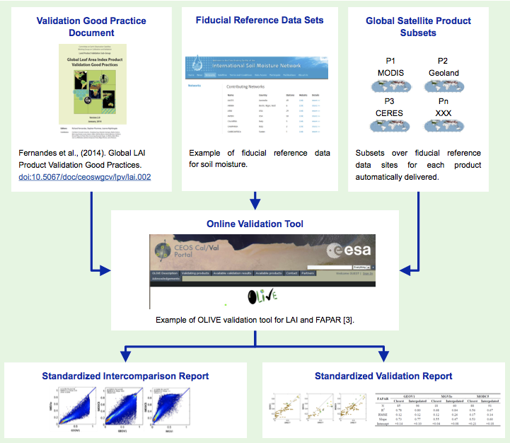
To reach validation stage 4, LPV has developed a framework for product intercomparison and validation. This framework is based on a citable protocol, fiducial reference data, and automated subsetting. Ideally, each of these parts will be integrated into an online platform where quantitative tests are run, and standardized intercomparison and validation results reported for all products used in the validation exercise. The goal is to implement this framework for each product variable. Information on variable-specific status of the implementation is available through the focus area pages.
LPV is currently in the process of selecting supersites with fully characterized land surface and vegetation cover for the parameterization of 3D radiative transfer models. These sites will serve as testbeds for in situ sampling strategies and product algorithm intercomparison.
Outreach activities of LPV include distribution of validation news through focus area email lists (see subscription menu in the left panel of this page) and regularly organized validation sessions at conferences, such as AGU and EGU (see announcements panel at top left).
LPV follows international terminology standards for the evaluation of measurement data
LPV Focus Areas
Subscribe!
LPV Focus Area mailing lists. Choose from the focus area pull-down menu.
Announcing...
AGU Fall Meeting, 9 – 13 December, 2024, Washington, D.C., USA
RAQRS'VII, Sep 23 – 27, 2024, Valencia, Spain, (abstracts May 1)
IGARSS 2024, 7 – 12 July, Athens, Greece.
43rd EARSel Symposium, 17 – 20 June 2024, Manchester, UK.
EGU General Assembly, 14 – 19 April, 2024 Vienna, Austria.
Land Product Validation and Evolution, June 12 – 14, 2023 ESA/ESRIN, Italy.
